have a look. maybe its my machine. to me its a bent image of the 360. not a sphere and it doesnt move.
Go to street view and then look at recent pix on the left side
your drone needs life insurance lol
ive been lucky so far. pigeons just randomly flying at it, and magpies.
Magpies are well known for flying up behind you and putting their beak into your skull.
Thankfully i didnt have much problem, i just flew it sideways. their 90 degree flying wasnt as good as mine. Magpies will make you bleed. Hate to think what they would do to a drone.
you think im kidding, i know i wouldnt believe it either lol watch till the end hahahahaa

So pretty over there. If i lived near scenery like that, id need 100 batterys lol
It may also be if you have edited it somehow. I actually took a screen shot to get a sphere in addition to the 360. It looks like the same picture when uploaded, but is treated differntly.
ive never done it b4 but i thought it would be like this …
anyhow 01:30 i best get a couple hours sleep lol
Wow, what did you do to piss off “Mother Nature” so much that she would send that bird to take you out and try so many times?
Ignoring that, Wow Again, that is some beautiful country and I would definitely be out there flying also…
One more point about bird attacks, not only is there that possibility of the bird breaking a prop, there is the possibility of the bird unlocking one of the motor arms and just like the broken prop, that is an unrecoverable situation.
Thank you for sharing that video and including the explanation and maps.
1 Like
There have been various studies when a person does something to aggravate a bird and it can include even small birds. It’s is possible that this person went too close to its nest and when the bird swooped down, the person defended themselves or even attacked the bird. When that happens, it’s all out war, man against nature…
Here is another video…

I think it all has to do with Metadata. When a 360 is copied from one device to another, for example: your DJI device (phone or tablet) onto another device like a PC, the metadata may not be recorded.
Right click on the file and Click Properties, Details, scroll down and look for the GPS Data. I think that this is the meta data that Google uses (and possibly others) that determeines if the photo is displayed as a Flat Photo or a 360-Photosphere…
Below are the properties of one of my 360s (on the Left Side) and the one I copied from the web site that Rover posted on the Right Side. Notice that no GPS data is included in the file’s details…
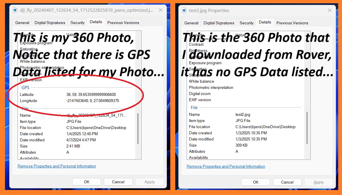
I have deleted Rover’s flat 360 that looks really weird when displayed flat…
I have posted one of my 360s (not of the park…) that I took locally to see if it posts like a photosphere… It’s not shown up yet… Look for a New photo a “360” with the contributor of “LoudThunder” It obviously is not one of this Park. I will remove it after a while. But if it posts as a 360, it due to the metadata being lost on Rover’s Photos…
Theres a bit of that aswell. They are just evil birds.
Another one is what we call the noisy minor bird. They will call you out pretty quickly lol
Ive walked around and cant see anything from you on google maps, at or near that location.
I just found the original and tried to post it and it gives me the error message as before.
Gods says no lol ill listen. It works on facebook. Yes the one i put to facebook has the exif data attached to it. heading out for the day soon. Sundays i take my mum to lunch. drones coming with me as always. If i get my way, there should be a new ship wreck video. Going to be in the 90s today, so have to wait and see if i can get in the air. Mum might want to stay local. catch you later
I also have not seen the 360 or the tower photo that I posted show up… I do not know what is the hold up… Below is my Google “Contribution” listing and it shows both photos… Notice that Google shows the map of the park showing the location of my 360. But they do not show up on the actual map…

Google use to had an app the you loaded on your phone/tablet that let you shoot 360s with the phone and then publish the photo and you picked the actual location and it did not have to be a place noted on the map, but they do not allow that nay more and the app no longer works…
Later
1 Like
Doesnt come up to me for some reason lol. o well.
I got on to the ship wreck i was after for like 5 minutes and out of nowhere the wind come up and was blowing hard. So alot less footage then i wanted. ill see if there is enough for a video.
Didnt get nearly as much as i wanted to because the wind come up.
No real need for neat editing lol
Music is as close to a sea shanty as i will ever get

i can do that. i hopped in my tardis and went to the pier today.
I can believe Ocean Eddies is open in this cold weather lol
You tell the gps thats where you are and magically thats where you are hahahahaahaaha
My little im here icon says im there aswell lol must be true.

Success, both of my photos have been posted on the St Kilda Adventure Playground site. The photo of the tower is one that I zoomed in from one of the original photos and screen shot it and edited out the person standing inside it. If you go to the photos and scroll through all of them it is the second to last… (or scroll backwards… L o L . . .).
The 360 that I took last April in the little town of Rescue is now posted in St Kilda Adventure Playground too. To see it, you have to go to “Street View and 360” and it is the last one. Success in spite of the GPS Metadata being from here in Virginia…
I’ll give them a couple of days for you to see and then I’ll take them down…
This is how I posted the 360 from my tablet, I copied the photo over to my Google Account Photos and then posted it (Grab and dragged it from Photos over to Post Photos) from there.
Mutton Cove was an interesting video, but it was too dark, but you know that, Right? I took the liberty of coping it using “4K Downloader” (free app to download YouTube Videos. I then lightened it a bit using “OpenShot Video Editor”, retitled it to give you credit and posted it on YouTube so you can see it. After a bit, I’ll delete, it’s yours and not mine to show…
By the way, I saw you waving at the drone at 2:15 in the video…
Later…
1 Like
I am not sure why you posted this. I’m guessing that you googled this area and then you clicked on one of the photos. The maps shows you where this is located and as you can see, the sign on the board walk and the inserted map agree, both in Virginia Beach (about 30-miles south of me…).
1 Like
you posted about you been in st kilda, and the little map had you there as well, so i thought i would do the same lol. You said you were in Virginia. So i found a beach with a pier. gps spoofed the pc, and now it thinks its at the beach.
On a different note i found your pic. Added my 360. it doesnt show on the map, just in recents like how i see yours.
I didnt relise that google pictures takes all of my pictures that i take on my phone and has them virtually. ive got sync turned off. so i just went in and manually deleted everything.
i actually like it in the darker mode. lightened with software gives it a washed look.
Each to there own. @2.15 im not on screen ? thats the container ship and tug boats ?
i will revisit this wreck at some stage. i wanted a lot more angles of it and the surrounding mangroves.
was nice for what i filmed then a squall come in and it was all over
I believe you are mistaken when you wrote, “So i found a beach with a pier. GPS spoofed the pc, and now it thinks its at the beach.” Your computer is showing the photo and where it was taken (the maps shows Virginia), not that it thinks you are there…

I Spoofed Google Maps and I said this photo was taken at St Kilda and as you can see, it shows the map of St Kilda, not Virginia… I fooled it and I will be removing it as it does not belong there. I only did this to see if there was a reason that you could not post 360s…

This link is to the real location of this 360 and as you can see, it shows the map of Virginia…
I am sorry for editing your video, I thought it was too dark for the mood of the scenery. As for the note about seeing you at the end of the video, I misread the time read out, you are at 0:33… I will also remove the video. As I wrote, it’s yours to show…

Well, I am now getting ready for tonight’s Polar Express expected to come through the area. We may get snow, sleet, and rain. Any case, the roads will be a mess.
Later
im normally somewhere in each shot. not by design, just lack of planning lol.
You tend to make sure you cant be seen. Ive noticed Finn does a cameo in all his vids lol
The blue landing pad seems to make an appearance in a few now as well.
Once im trying to make things look a little more professional, i might edit out the landing pad, and myself.
On my agenda now is getting a night flight in.
Forecast for early morning b4 the sun comes up is about 20km/h / 12.5mp/h winds, which is not huge, but id prefer a little more sedate.
Goals with the night flight will be;
:testing out the night mode, as set up in the rc2.
:seeing how easy it is to navigate in low light.
:seeing how bright the under side white light is.
:seeing if i have what it takes to go high and get a night time Hyperlapse.
With the Hyperlapse i assume it will require a very calm night. just a little movement and it will make it look funny.
If i like the night flying, might fashion up landing lights on the drone pad.
Been thinking of a wind indicator as well. a piece of dowel with printer ribbon would do the job. just as a visual indicator.
Stay safe in the snow. You know the Australian has never seen snow falling ? lol
Do drones like the cold ? i got a mate in Syricuse who lets me have access to his shop camera network. so alot of the time while im sweltering in the heat i have his parking lot cam up showing the snow. looks like they had a lot last night.
Be safe