I curius about the Flightlog map location ins a red line and where that end, is that the location it crash?
i got Compass error and Yaw error.
I curius about the Flightlog map location ins a red line and where that end, is that the location it crash?
i got Compass error and Yaw error.
We need to see the flight log to answer any questions for you. You can upload your .txt log to the link below and share a link back here to that.
Log Viewer
To answer your question most likely not. Once the aircraft switched to ATTI mode, you basically ceased attempting to control it and allowed it to drift away with the wind. The aircraft was still drifting at the end of the flight log and was at almost 400ft in altitude. The issue of the Yaw and Compass error, judging from the view of your takeoff location was full of mettalic objects in the area, including underground concrete re-bar it apperas. You still had plenty of battery remaining and I suspect it drifted much much farther than the last signal in the log. Had you steered the aircraft back to you immediately upon the first Yaw Error, you would have been fine. Sadly, it looks like this one is quite lost.
ohh damn ;-(
We can possibly do a rough calculation of where it possibly landed, but that location can not be guaranteed 100% accurate.
We can try thanks
i must swich to ATTI mode by a mistake
No, you did not. The aircraft switches to ATTI automatically with a compass error, because it cannot accurately position itself.
Thanks for all help, next time i be more careful when i buy new
If you would like for us to do a rough location estimate, feel free to ask. Several of us around can do that for you. But as I said, the search area will not be pin point accurate and it may or may not be something you wish to pursue.
how much for that?
There is no cost for that. This is a help forum. Any assistance you are given here is completely free and voluntary from those of us who do so.
I would like very much try that help, because Drone was not old, and its expensive.
This may take a while. It is Holiday time here in the US, but we will get back to you. Let me see if @msinger or @BudWalker has time to do this. I may as well but it might be a while.
Thanks anyway i am patient
This is a very rough calculation, assuming that all variables are constant and a landing percentage of 10% battery. Assuming the drift direction and speed remained constant at an average of 10m/s, the aircraft would have drifted for quite a long way before auto landing and could be any where within the area below. As I said, it is only a guess and uncertainty is always a factor.
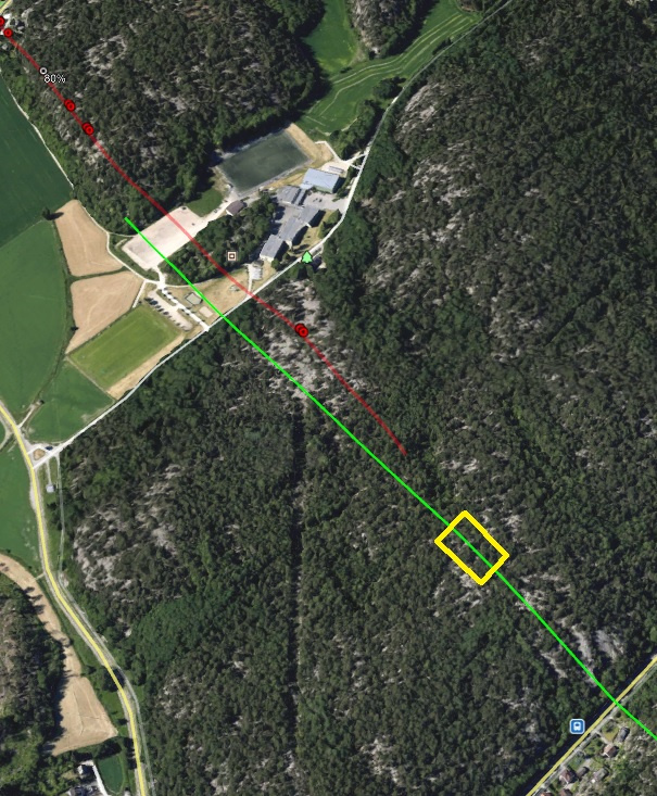
Since the aircraft was flying in ATTI mode at the end of the flight log, it would have landed at its current location after the remote controller disconnected. Assuming the remote controller disconnected at the end of the flight log, the aircraft would have drifted along with the wind for up to about 49 seconds while it was descending toward the ground. The actual time it took to land would likely be less than that since the terrain was higher than at the takeoff point.
The aircraft was drifting roughly in the direction of the green line in the image below. The yellow box is the furthest point I think it would have reached.
The last recorded location was 59.187483, 10.924945. The furthest possible point I think it would have reached is at 59.187723, 10.926245. I’d start searching at the furthest point and then walk toward the last recorded point. You can plug those coordinates into the map app on your mobile phone.