Hi! Could someone please help me to analyse my last flight with my Mavic Mini (4 days old). I lost it, and I couldn’t find it…
I was flying and suddenly I lost the signal and it did not return to home point. In “find my drone” the last gps coordinate was totally crazy!
Unfortunately, the analysis is easy and straight forward. The aircraft was functioning completely normally. Basically you flew it away yourself. You were so high in altitude that the winds were too strong for return to home. Why you issued that full aileron and flew it away at such a high altitude is anyones guess.
Note the high wind warnings you recieved.
329.8,VENTO MOLTO FORTE. IMPOSSIBILE ATTIVARE IL RITORNO AUTOMATICO. SCENDERE DI QUOTA IMMEDIATAMENTE E RITORNARE AL PUNTO DI PARTENZA MANUALMENTE.)
329.8,VENTO MOLTO FORTE, IMPOSSIBILE ATTIVARE IL RITORNO AUTOMATICO. SCENDERE DI QUOTA IMMEDIATAMENTE E RITORNARE AL PUNTO DI PARTENZA MANUALMENTE.(CODE: 30149)
329.8,ALLERTA VENTO FORTE
Thank you for your time, really appreciate. I know i was too high, and it was my mistake. BUT, I have 2 questions:
when I lost the signal the drone was 105m high and about 170m far from me. What happened then? did he fall straight to the ground at that point? Or he tried to return to home? where can I try to find it?
in “find my drone” section, the last GPS location is about 14 kilometers away from the point where it lost the signal: is it possible? I think it is very strange, considering that itshould have crossed a mountain more than 900 meters high from the home point.
I know I have no chance to find it, but I would still like to try.
Thank you again,
Just to make the 2nd question clearer, this is a map in which you can see the last GPS location (45.98287, 8.31652) and the last point of the recorded flight.
The last records, this for 15 seconds, only full stick down.
Speed stopped (roll stick zo zero), distance out 170 meters to 171 meters with only minor pitch and roll angles.
So MM was able to hover steady in position with minor angles = less wind, thus a RTH with normal max pitch down angles must have given forward speed towards home.
Cant answer your question as to why “Find my Drone” is incorrect. The last location in the .txt log is:
45.95924061,8.13626624 . The same location as shown in the uploaded log and flight path.
Secondly, for @JJB info, this is the Airdata wind report.
I don’t want to start a fight between you two, but I’m missing something (besides the drone) is it possible that the last detected position in “findy drone” is wrong? in the sense, is it technically possible? @Fly_Dawg where do you think my research should be focused? tomorrow I would like to go back and take another look, even if hopes are practically nil.
Thank you guys, you are great!
Wind data in general is not always correct in mountain areas
Craft was close to the ground end of the flight…
Hovering in that wind and holding postion with < 3 degrees pitch and roll drone angles = not to much wind around the MM.
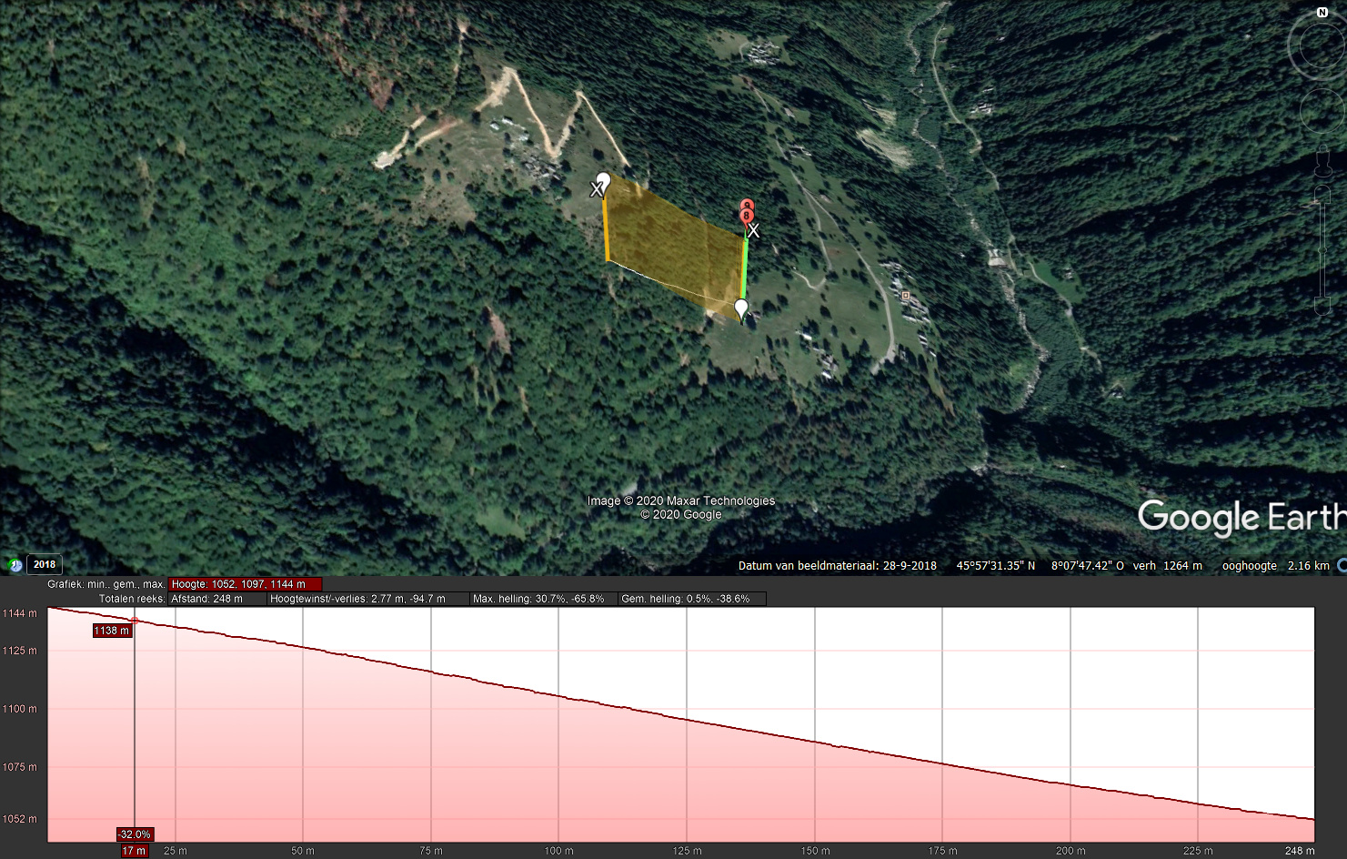
Checked the fly area, possible that the MM crashed, fly path is uphill,lowering to 105 meters relative from start point, where the last position is roughly 1144 - 1052 meters higher than start point.
last position = 45.95924100, 8.13626700.
BTW drone heading South with camera 10degrees up, so on the screen only free air was seen, not the mountain…
There is no argument. Its good to have multiple inputs on analysis. Again, I cant explain why “Find My Drone” appears to be incorrect. Maybe @JJB B could input on that…
About “find my drone” ; if drone is landed somewhere in full connection to the RC/mob device than the last record in the flightlog.txt is the same as in “find my drone”. (tested this out myself)
Flightlog recording stops as the motor are stopped, in normal situation or due i.e. a crash.
If the drone is still powered and (re)connected than the DAT file is still saving data.
So possible in this flight ; connection failed; no more data saved in the flightlog.
I think it did crashed, motors stopped, if after that (when MM tumbeld down) the connection was restored, data is written in the DAT file. Not tested out myself but logic tells me that the Find my drone uses DAT data.
If user like, upload in the cloud somewhere the DAT file ; its FLY020.DAT found on the mobile device.
BTW seen another case in Germany where the find my drone postion was kilometers away from the crash impact. This drone crashed top of trees and did fall down along a mountain. GPS data was in error falling down.
Hi @JJB! thank you for your observations. I can’t find the DAT file on my mobile. The MCDatFlightRecords is empty!
BTW, my point is that the find my drone position was impossible to reach for MM: it should have crossed a mountain climbing over 900 meters from the connection failed point! If you want, this is the map of the area: Last flight MM - Google My Maps
I wrote to DJI support, I’m waiting for an answer (but I’m very low confident about that).
Ok, analysis complete. My MM hit a tree during its RTH, I have a video of that (very funny). I’m not sure the wind mattered in this case.
BTW, lesson learned! Thank you @Fly_Dawg and @JJB for your precious support!
Cheers!
Hi, wind did mot play a role in this incident. during lowering your MM it was steady in a hover with minor pitch and roll drone angles, So no wind that time in that position.
Watched the video, guess line of sight for the radio signal was hampered by trees, loss of contact good to see as drone stopped moving (quiet in the hover) turning towards home and…