Hi all, I took my Mini up today and the wind took it and now it’s lost. I spent 90+ minutes searching for it around the last marked spot but I think that was just where it lost connection and/or ran out of battery – I suspect it was still in the air and continued to blow away as it fell.
If anyone is able to give me any suggested projections of where to search from here it would be super appreciated.
No need to tell me what an idiot I was, I’ve already figured that part out and if I ever recover the little drone I’ll be giving it to someone qualified to fly it
You may very well be qualified to fly it, you probably just didn’t understand what it’s limits are. That’s something that can be corrected. Hope you find it!
@Fly_Dawg Thanks, I thought it looked like complete nonsense too but obviously I have no experience with these things. I’ve tried to upload it twice and it’s the same — I think it must be corrupted? The drone lost contact with the controller for a few minutes during the flight and then again at the end. Not sure if that’s what caused the messed up data.
You might try locating the .dat in lieu of the .txt file. You can upload that directly here.
These are retrieved by the same method as the TXT logs. Under both iOS and Android they are in a subfolder, MCDatFlightRecords , in the folder that contains the TXT logs.
@Fly_Dawg I’m using the DJIFly app, not the other one. I can save the TXT logs via iTunes per the instructions, but when I open the subfolder MCDatFlightRecords, it is empty.
Also as a new user in the forum I cannot upload attachments directly in my message here.
@JJB thank you for the analysis! I already canvassed that area pretty well but it can’t hurt to go back and have another look. I know the RTH thing was a mistake – my thought was that I wanted to avoid any trees etc. Obviously I’ve learned a lesson the hard way.
@cheddarman Just as a piece of advice, you may need to look a bit closer at the data, RTH was indeed initiated, however distance continued to increase, even with the aircraft pitched down to almost 25 degrees. The aircraft was struggling in the wind at that altitude. And agreed with @JJB, but possibly much farther distance.
I can see that at 1:59.3and again at 3:37.3 both of which didn’t happen.
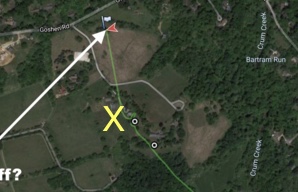
But where was his take-off, top left, by the flag or bottom right by the buildings. The initial data doesn’t give Log/Lat so I’ll go into the next level, if I can remember how😳
Hopefully this image shows up, the take off point is actually closer to the yellow X, near the small buildings halfway up the driveway.
Thanks for all your responses. I searched at the last recorded location and in the adjacent fields (where @JJB marked the yellow dot) immediately after it happened but with no luck. I’m wondering if it continued flying farther on …
Lots of trees around the recorded end of flight area and not a very big target to see if it’s in the top of a tree. Have you got a mate with a drone who could do some over flying to see if it’s visible from up there?