Hi,yesterday towards the end of my flight, I flew into a railway bridge, followed the tracks nicely, then for some reason the drone started to turn sharply to the left, and then I hit a pillar and the drone fell into the river, of course.
The flight log didn’t show that I pulled the drone to the left, so could it be the fault of the drone?
Maybe it’s worth complaining on the DJI forum?
Unfortunately it looks like you did command a Left Roll ~12 Seconds before Impact with the pillar. Hard to say definitively without additional data, if that was indeed the cause. I see no errors from the aircrafts prospective.
The top chart shows the turn (green) while the bottom chart shows no rudder or aileron inputs.
I suspect this incident may be related to a distorted geomagnetic field caused by the steel in the railway. This would be evident in the .DAT log for the flight. If the Fly app is set to not synch flight data with DJI then the .DAT will exist on the goggles and can be retrieved. That .DAT can be retrieved by using the procedure found here https://fpvdronepilots.com/threads/dat-available.4225/
The name of the .DAT will be
FLYxxx-060-2023MMDDHHMMSS.DAT
Using DJI Assistant 2 will yield an encrypted .DAT; i.e. useless for our purposes. The procedure described in the above post is the only known method that produces a usable .DAT.
The video helps in this case. It appears that @BudWalker may be correct. In the video the quick drift began approx 1 second before loss of data. My question would be why an approx 20 degree CCW yaw would cause a drift to the left. My gut tells me it’s in relation to the flight speed but even that doesn’t make complete sense. I would have expected a deviation in roll for that…
It’s tempting to conclude that the geomagnetic distortion caused by the steel construction contributed to this incident. But, the Avata flew for about 10 secs inside the steel structure without incident and then rolled CCW without any apparent changes in the distortion.
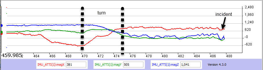
At about 470 secs the Avata rotated CCW and started entering the steel over structure. At 475 secs the entrance was completed and the flight path through the steel over structure was established. Magnetometer data didn’t vary much until about 486 secs when the uncommanded roll happened.
Thank you very much Rowland the help and the way you explained things.
I’m very disappointed at this time with the avata.
I really liked this one.
Thank you very much one more time,maybe I can use those data as evidence.
Have a nice day!
I am pretty new to this hobby, sport whatever but I have expirience building large industrial microwave systems and as soon as I read steel structure that was like a light going off. In his case I believe the harmonics and standing waves etc. created on the structure was the culprit. But I too want to say that Dji standing up and making it right gives me a less negative feeling about them. I like many have had major headaches trying to get my P4PP to load maps for weeks and although I did get a guy named Joe who I had confidence in but, Unfortunately, I had one question to clarify and got a reply from someone other than Joe who I replied to. So I asked her to forward it to Joe please. She replied with send me a video of my issue…
Somehow, sending a video of my screen saying “Update not Installed” seemed like a waste of time.
Anyway, kudos to Dji for treating Nyehe like a valuable customer. I’m happy they made it right for you Nyehe.
Well anyway… I’m headed out now to build a smoky fire at the destination I was wanting to fly to using the maps.
A bit low tech I guess but accomplished none the less…